- City Fajr Shuruq Duhr Asr Magrib Isha
- Dubai 04:31 05:49 12:21 15:48 18:47 20:05

Update: As per 4am UAE time, Tropical Storm Ashobaa was 170kms away from Oman's Southen Al Sharqiya coast, with maximum surface winds up to 82kms per hour.
However, its convective band of rain clouds was only 60kms away from Masirah Island.
According to the Oman Meteorology department: "The storm will continue to move towards coastal areas between Ras Al Hadd to Masirah Island, associated with moderate to heavy rainfall and fresh strong gale winds over the governorate of Southern Al Sharqiya and gradually extending to Northern AL Sharqiya, Al Wusta, Muscat, Al Dhakilia and Southern Al Batinah during the next 48 hours.
"The seat state will continue to be rough to very rough over the Sultanate's coast with maximum wave height between four to seven metres,"
The Oman Met office stated there are indications this system would weaken as it crosses Oman's coastline.
The Public Authority for Civil Aviation in Oman is advising people to stay away from low lying areas, and avoid crossing wadis.
Fishermen and sea goers are also advised to avoid venturing into the sea.
The UAE has stated the east coast of the country would be indirectly affected with connective clouds giving way to rainfall in the area.
Fresh winds, coupled with fog in the western region, is the forecast over the next 24 hours.
The National Centre of Meteorology and Seismology for the UAE stated: "The impact of Tropical Storm Ashobaa on the country is expected to raise the sea state over the eastern coast of the UAE, where the Oman Sea will continue to be rough to very rough, in addition, an increase in the amount of clouds to the east in specific may be embedded with few rain over the south eastern region."
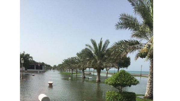
Waterlogging in UAE
There are reports of waterlogging in parts of Kalba and Fujairah, which authorities are attributing to Ashobaa.
ADP Water Rescue Team Braces for Tropical Storm Ashobaa in Fujairah pic.twitter.com/21h4cIZlIA
— MOI_UAE (@AbuDhabiPolice) June 10, 2015
On its official Twitter account, Abu Dhabi Police has also stated its water rescue team is bracing for Ashobaa in Fujairah.
Video Courtesy Abu Dhabi Police Twitter account.
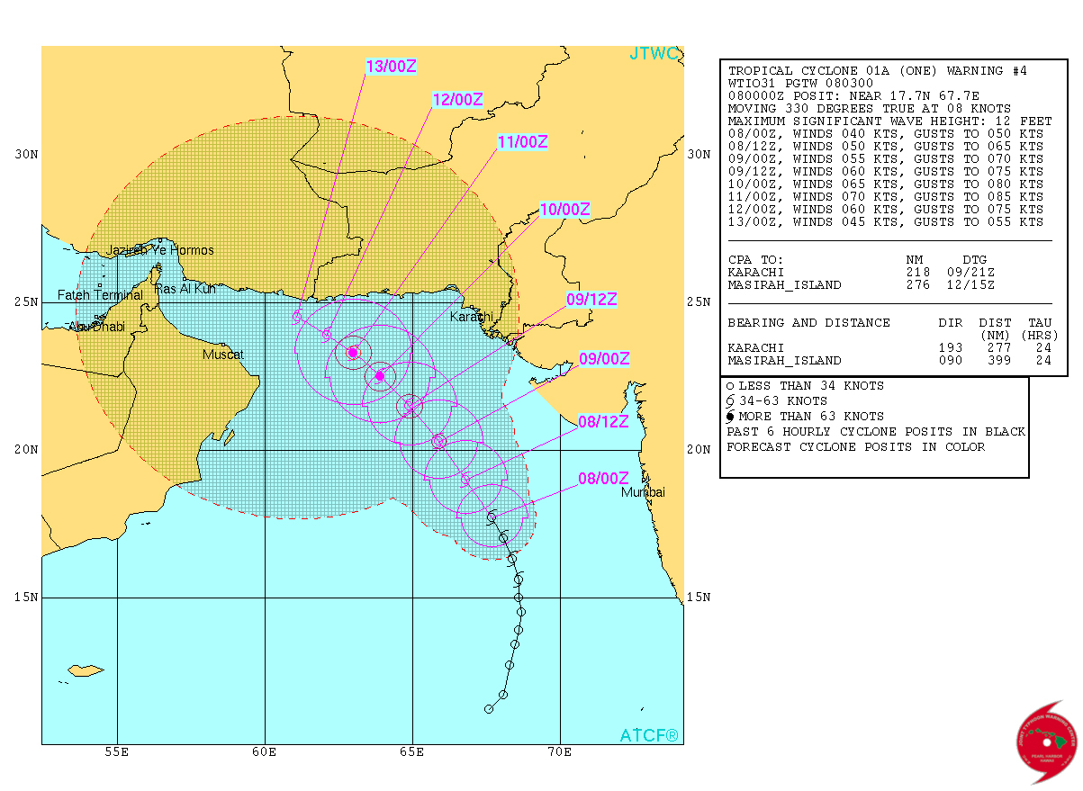
According to the morning estimates, Cyclonic Storm Ashobaa has steered its path across the Arabian Sea, holding position approximately 613 kms from Fujairah, while 270 kms southeast of Sur and 310 kms northeast of Masirah Island.
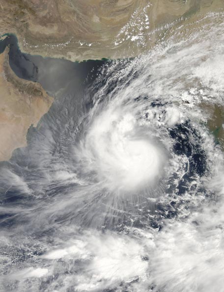
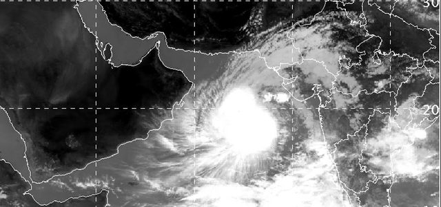
NASAs Aqua satellite captured this visible image of Tropical Cyclone One (01A) in the Arabian Sea approaching the Gulf of Aden. Credit: NASA Goddard MODIS Rapid Response Team (Supplied)
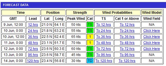
The US Navy’s Joint Typhoon Warning Center (JWTC) latest forecast estimates the storm will make landfall in Oman on June 11, with initial wind speeds reach 140 kms per hour, before losing intensity.
The UAE has reiterated its earlier statement, with the National Centre for Meteorology and Seismology (NCMS) saying its forecasted weather charts and some models indicate the continuity of the tropical storm movement toward northwest to get closer to the coast of the south eastern province in Oman by Thursday morning, with a probability of scattered heavy rain and a fresh to strong winds.
It added: “The impact on the country expected to be indirect, that impact will rise the sea state over the east coast of the UAE, in addition, an increase in the amount of clouds, especially on the eastern mountains.”
The NCMS also warned residents of fresh southeasterly winds and rough waters in the Strait of Hormuz and northern Oman Sea.
Emirates, meanwhile, has stated it is also closely monitoring the situation.
The airline told ‘Emirates 24|7’: “Emirates is currently monitoring the development of tropical storm Ashobaa, which is currently situated in the Arabian Sea. Emirates’ operations are running on schedule at the present time and are not affected by the storm. As with all severe weather systems, we are continuing to monitor the storm and its path.”
Oman, Pakistan issue warnings
The Muscat Municipality is asking residents to cooperate with authorities during emergencies, and report situations on its helpline, stating: “You can also contact us in Muscat on 1111 or through social networking channels.”
An dark, overcast sky across Oman’s eastern coastline also gave way to downpours, with the Oman Meteorology department reporting sporadic rainfall in southeastern provinces.
The met office also warned of flooding in some parts, saying in its last update: “Although there are different possibilities for the Tropical Storm tracks, it is more likely to approach South Al Sharqia’s coast during Thursday morning, with chances of moderate to heavy rain associated with fresh to strong gale winds over Governorates of South Al Sharqia, North Al Sharqia, Muscat, Al Dhaklia, Al Wusta and South Al Batinah up to Friday afternoon.
“The sea state will gradually become rough over the Sultanate’s coasts, with maximum wave heights ranges between three to six metres (20 feet) during the three coming days.”
The Public Authority of Civil Aviation or Paca has warned residents of Oman to stay away from low lying areas, avoid crossing wadis.
Fishermen and seagoers have also been told to avoid the Oman Sea over the next few days.
The Indian Meteorological Department forecast, meanwhile, stated there would be further impact on June 11 as the storm makes landfall.
It said: “The system continues to move in nearly westward direction and cross Oman coast as a cyclonic storm between latitude 21.50 N and latitude 22.50 N south of Ras Al Hadd in the evening of 11 June 2015.”
The Pakistan Meteorological Department has placed Ashobaa 400 km east-southeast of Muscat, saying: “The Tropical Cyclone over west-central Arabian Sea has further moved west-northwestward during past 12 hours and now lies centred about 650 kms southwest of Karachi and 400 km east-southeast of Muscat.
“The Tropical Cyclone is likely to intensify further during next 12 hours and keep moving west-northwestward towards Oman coast.”
It added the sea conditions are likely to remain rough along the Sindh coast and very rough along Makran coast (Pasni, Gwadar and Jiwani) accompanied with strong winds and maximum surge of 12-15 feet.
The Cyclone Warning Centre (Karachi) of PMD has warned the fishermen of Sindh and Balochistan to not to venture in open sea until Thursday.”
Under the influence of this system an extended clouds band prevails over Makran coast and south Punjab due to which scattered rain and thunderstorms with isolated heavy falls are expected in southwest Balochistan (Pasni, Gwadar, Turbat, Kech and Jiwani) during next 24-36 hours (with gradual increase in rainfall intensity from moderate to heavy) and over south Punjab.
Trajectory of the storm
According to the US Navy’s JWTC June 10 update, the storm’s maximum wind speed was 55 knots (102 kms per hour), with gusts of 70 knots (130 kms per hour) over the open water only.
The JWTC states the weather system has moved westwards at five knots over the past six hours; the Tropical Cyclone has slowed down significantly as it begins to transition.
It added: “The system will begin to accelerate westward again over the next 24 hours (June 11) as the new strength builds in and assumes steering.
“Expect modest intensification in the near term prior to the system reaching the coast of Oman and then steadily weakening…”
Ashobaa will dissipate as it moves inland, it added.
Earlier, the Indian Meteorology Department has now termed Ashobaa a Cyclonic Storm, which is less than 400km east-southeast of Sur, and less than 550kms east-southeast of Muscat.
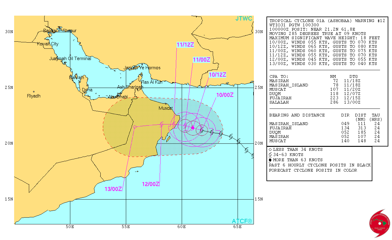 A graphic on Ashobaa with the latest distance. (US Navy)
The eastern coastline of Oman is bracing for Tropical Storm Ashobaa as forecasters state the weather system is expected to make landfall by Thursday morning.
Precautionary measures have already been implemented, with the Oman Municipality also setting up a 24-hour call centre for emergencies.
In its last update, issued on Tuesday 11pm UAE time, the Oman Met office stated the storm was approximately 500km off the South Al Sharqia coast, with maximum surface wind speeds of 45 knots or 83km per hour.
The statement added: "Although there are different possibilities for the Tropical Storm tracks, it is more likely to approach South Al Sharqia's coast during Thursday morning, with chances of moderate to heavy rain associated with fresh to strong gale winds over Governorates of South Al Sharqia, North Al Sharqia, Muscat, Al Dhaklia, Al Wusta and South Al Batinah during the period of Wednesday afternoon up to Friday afternoon.
"The sea state will gradually become rough over the Sultanate's coasts, with maximum wave heights ranges between three to six metres (20 feet) during the three coming days."
The Public Authority of Civil Aviation or Paca has warned residents of Oman to stay away from low lying areas, avoid crossing wadis.
Fishermen and seagoers have also been told to avoid the Oman Sea over the next few days.
On Tuesday, a resident of the coastal Muttrah district of Muscat spoke to Emirates 24|7 stating the Scout Wing of the Royal Oman Police was also issuing warnings in buildings along the coastline.
The Oman Municipality has also issued circulars to government entities, informing them to take on precautionary measures.
UAE
The UAE's National Center of Meteorology and Seismology or NCMS has stated the UAE will experience indirect impact of the storm on the country's east coast.
In a statement, it said: "The impact on the country is expected to be indirect, with a rise of the sea state on Thursday morning.
"In addition, an increase in the amount of clouds to the east coast is expected, especially over the eastern mountains."
The NCMS further warned of fresh southeasterly winds and rough seas in the Strait of Hormuz and the northern Oman Sea.
The US Navy's Joint Typhoon Warning Center has stated the Tropical Storm would intensify in the next 12 hours, but is expected to weaken in 24 hours as it makes landfall in Oman.
The storm is expected to dissipate in 48-72 hours.
Earlier reports
The National Center for Meteorology and Seismology (NCMS), according to Arabic newspaper 'Emarat Al Youm', has said that the tropical depression located on the Indian coast can begin its impact on the UAE as early as today evening.
"This will be in the form of active winds on the east coast, leading to the high sea waves, from orbital depth of the tropical strom called 'Ashobaa'," the report states.
Oman on watch
Oman is bracing itself as the cyclone hurtles it way across the Arabian Sea.
The Public Authority for Civil Aviation (Paca) said in its last update on Monday evening it was monitoring the storm closely but the direction of the storm was yet to be determined.
It further warned of wind speeds hitting highs of 74km per hour, adding: “The latest weather analysis indicates the possibility of deepening of the tropical storm while moving north to northwest direction during the next two days without any direct impact on the coastal areas of the Sultanate.”
It continued: “Although there are different possibilities for the Tropical Storm tracks. It is more likely to move north towards Pakistan’s coasts, with indirect effects on the coast of Oman Sea and South Al Sharqiya by clouds activation, rain and rising sea levels.”
The Tropical Storm Risk Centre has indicated in its trajectory data that the storm could affect Sur, with the intensity hitting a Yellow Risk or a Category 1 Severe Cyclonic Storm that could see wind speeds range between 120-150kmph.
15-feet high waves off Pakistan
Pakistan’s Met office has issued a cyclone alert, expected waves reaching height of 15 feet, as the country could bear the brunt of the storm as it makes landfall.
In its Tuesday bulletin, Pakistan’s Met office stated: “The Tropical Cyclone Ashobaa in east-central Arabian Sea has slightly drifted northwestward in last six hours at a speed of 10kmph and now lies centered about 700km south of Karachi.
“The Tropical Cyclone is likely to intensify further and move northwestward in next 24 hours.”
The Met department further stated: “The sea conditions along Sindh-Makran coast are likely to remain rough to very rough occasionally high associated with stormy winds from Monday afternoon to Friday.
“Maximum tide height is expected 12-15 feet. Cyclone Warning Centre (Karachi) of Pakistan Meteorological Department has warned the fishermen of Sindh and Balochistan to not to venture in open sea from Monday afternoon to Thursday.
“While fishermen of Balochistan are advised not to venture in open sea from Tuesday to Friday.”
Under the influence of this system thunderstorms of moderate intensity (25-35 mm) accompanied with winds of 30-40 kmph are expected to hit Karachi, Hyderabad, Mirpurkhas, Tharparker, Thatta, Badin and Sujawal districts of Sindh during next 24-48 hours and after 36 hours in south Balochistan, it further added.
India braces for strong winds
In a statement, the IMD said: “The cyclonic storm Ashobaa over east central Arabian Sea has moved in a north-northwesterly direction and lay centred at 5.30am IST (4am UAE time)of 9 June 2015 near latitude 20.00 N and longitude 65.00 E, about 830 km west of Mumbai, 570kms west-southwest of Veraval, 640kms east-southeast of Sur, Oman and 800kms east-southeast of Muscat (Oman).
“The system would move north-northwestwards and intensify further into a severe cyclonic storm during next 24 hours and it would move northwestwards thereafter.”
Under the influence of this system, rainfall would occur at most places over south Gujarat during the next 24 hours and over coastal Karnataka, Konkan and Goa with isolated heavy falls during the next 48 hours, IMD further added.
Strong winds speed reaching 70-80kmph gusting to 90kmph would prevail along and off Karnataka, Goa and Maharashtra coasts during next 24 hours and 95-105kmph gusting to 120kmph during subsequent 24 hours.
Sea condition would be very rough to high along and off Karnataka, Goa and Maharashtra coasts during the next 48 hours.
Fishermen along and off Karnataka, Goa, Maharashtra and Gujarat coasts are advised not to venture into the sea during next 48 hours. Fishermen out at open sea are advised to return to the coast.
Kuwait maritime traffic suspended
The Kuwait Ports Authority, KPA, has announced that navigation has been suspended at the Shuwaikh, Shuaiba and Doha Ports due to bad weather, fast wind and dust.
Head of the guides department at the Shuwaikh Jassem Al Mutairi told Kuwaiti News Agency, Kuna, that work has temporarily come to a halt at the port.
"Visibility was below two nautical miles and wind speed reached 32-34 knots. The decision observes security and safety reasons," he said.
According to the International Maritime Organisation (IMO) Law, navigation has to stop when visibility falls to less than 3 nautical miles, Al Mutairi said.
At the Shuaiba port, visibility is less than a nautical mile and wind speed is -25-30 knots, according to Acting Deputy Director of Navigation Operations Captain Shuaib Al-Ali.
At present, three vessels are waiting to enter the port, and other two ready to leave as soon as weather gets better, he added.
Monday, June 8, 2015
36-hour watch
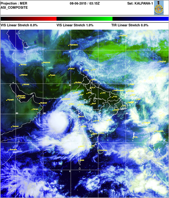
The latest satellite images and observations in addition to weather reports from the main regional centres indicate that the depression has been deepening into a tropical storm named (Ashobaa) and has moved towards the north and northwest from its original position located to the east side of the Arabian Sea during the last six hours.
It is currently located at a latitude of 17.5N & 67.5E about 960km from Masirah Island (Oman), with surface wind speed between 60-80km/hour.
It will continue move north-northwestwards and intensify further during next 36 hours in to a strong tropical storm. NCMS said it will keep watching this weather case, as it is well known that such weather cases are quickly changeable.
Pakistan Meteorological Department has issued a weather update saying: “Under the influence of this system rain and thundershowers are expected in Karachi, Hyderabad, Mirpurkhas, Tharparker, Thatta, Badin and Sujawal districts of lower Sindh in 24-48 hours and after 36 hours in south Balochistan.”
India’s Skymet Meteorological Department also updated its alert, stating: “Weather system in Arabian Sea has gained strength, as the satellite images are showing cloud configuration, which is almost same to that of a tropical cyclone.
‘Tropical Cyclone’
The weather system that has formed over the Arabian Sea has been upgraded from a ‘Deep Depression’ into a ‘Tropical Cyclone’ by the US Navy’s Joint Typhoon Warning Centre (JTWC), even as Pakistan issues an alert across its southern coastline.
The Cyclone is being referred to as 'Ashobaa'.
According to the latest trajectory, the eye of the cyclone is approximately 970kms off Oman’s coastline while its outer sphere nearly 510kms off Masirah Island as per the Indian Met Department and the JTWC, respectively; the neighbouring country, along with the UAE, remain on alert as this weather system gathers steam over the Arabian Sea.
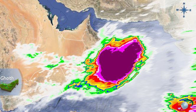
 Cyclone satellite imagery issued by Indian Met Department
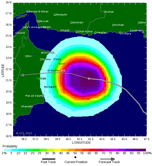
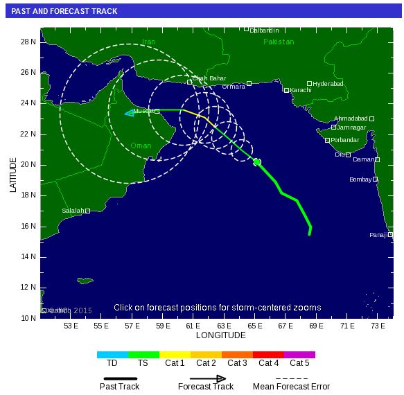
 Tropical Cyclone trajectory issued by the JWTC
Pakistan and Iran
The Pakistan Meteorological Department (PMD) has now upgraded the deep depression over east-central Arabian Sea into a Tropical Cyclone (01A), which now lies about 750km south of Karachi.
It further added: “The sea conditions along Sindh-Makran coast are likely to remain rough to very rough occasionally high associated with stormy winds from Monday afternoon to Friday. Cyclone Warning Centre (Karachi) of Pakistan Meteorological Department has warned the fishermen of Sindh and Balochistan.”
As per its current trajectory, Pakistan and Iran could be impacted by high waves and strong winds, with the former issuing a cyclone warning, along with advising fishermen to refrain from venturing out into the sea until Friday, June 12.
In his last update issued 8.30pm UAE time on Sunday, Naeem Shah, Chief Meteorologist, Cyclone Warning Centre, Pakistan Meteorological Department stated: “ The well-marked low pressure area over east-central Arabian Sea has rapidly intensified into a deep depression during last 12 hours and now lies around 1,000kms south of Karachi.
“This system is likely to intensify further into a Tropical Cyclone in next 12-24hrs and likely to move in northwestward direction.”
He added: “The sea conditions along Sindh-Makran coast are likely to remain rough to very rough occasionally high associated with strong squally winds from Monday afternoon to Friday.
“Cyclone Warning Centre (Karachi) of Pakistan Meteorological Department has warned the fishermen of Sindh, as to not venture in open sea from Monday afternoon to Thursday. In Balochistan, fishermen of Balochistan are advised not to venture in open sea from Tuesday to Friday.”
India remains watchful
According to the meteorological analysis issued by the IMD on Monday, the depression over east-central Arabian sea has intensified into a deep depression and moved north-westwards and lay centered at 4am of June 8 2015 near Latitude 17.5°N and Longitude 67.5°E, about 590kms southwest of Mumbai, 480kms southsouthwest of Veraval and 970kms east southeast of Masirah Island.
It would move northwestwards and intensify further into a cyclonic storm during next 24 hours.
Meanwhile, India’s Skymet Meteorology Division further stated: “The system is intensifying rapidly and the cloud configuration is indicating all the features of a tropical storm. We now expect the weather system to strengthen into a tropical storm shortly.
The division further stated if it forms into a cyclone, it will be named Ashobaa, adding: “As the system move northward, it will move into the cool water of Arabian Sea that generally does not support the intensification of such systems. But we need to wait and watch before reaching any conclusion.
“This weather system has been responsible for the onset of Southwest Monsoon over Kerala on June 5 and its further advancement. Kerala had witnessed heavy rainfall on June 5 and 6 on account of the system.
“But as the system shifted slightly away from the coast, intensity of rain over Kerala, Karnataka and Tamil Nadu also reduced.”
Trajectory and timeline
The JWTC, which has already tagged this as a Tropical Cyclone, further stated in its Monday update, its initial intensity remains at 40 knots or 74km per hour, ‘based on an overall assessment of the current structure’.
It further added: “The Tropical Cyclone 01A is currently tracking along the western periphery of a northwest-southeast oriented high located over Central India.
“After 36 hours, a northeast-southwest oriented upper level trough passing to the north will weaken the strength and modify the steering environment causing the Tropical Cyclone 01A to slow down.”
It added that in 72 hours or by Thursday, the system will track west-northwestward with the upper level conditions expected to improve, allowing the system to further intensify to a peak of 70 knots or mearly 130km per hour.
Following this, by Saturday, the cyclone is forecasted to weaken. The JWTC has also stated waves could reach heights of 12 feet.
Click to read: Tropical depression over Arabian Sea
![]() Follow Emirates 24|7 on Google News.
Follow Emirates 24|7 on Google News.
![Ras Al Khaimah...NCMS has warned of low horizontal visibility due to dust and sand [Pic Courtesy: Mohammed Hanif/Al Bayan]](https://www.emirates247.com/polopoly_fs/1.593100.1452244621!/image/image.jpg)