- City Fajr Shuruq Duhr Asr Magrib Isha
- Dubai 04:36 05:52 12:21 15:49 18:45 20:02

Pic courtesy: wam
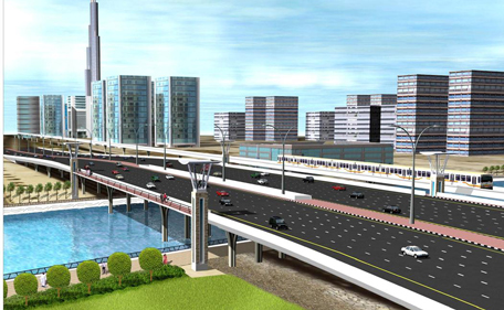
Artist’s impressions of the Dubai Water Canal Project show scenes of families enjoying picnics, bike rides and pleasant strolls by a sparkling blue canal running through Al Safa Park to Jumeirah Beach Park - this is Dubai's latest ambitious project.

This new attraction might have not have escaped the attention of Dubai residents.
From Business Bay to Jumeirah Beach Park, the ground is gearing up for the Dubai Canal project.

Most notably, the area on either side of Sheikh Zayed Road is in full swing for extensive road works. Six lanes of traffic will be temporarily relocated to make way for the construction of the bridge.
Meanwhile, further down towards the beach front early signs of construction show drastic changes in the landscape.
Tenants are moving out, building doors are closing and in some areas the digging has started.

Emirates 24|7 followed the track of the waterway bringing you the first hand information of the work in progress and have captured what will soon be gone to replaced by the sparkling canal.
The starting point of the project is the end of the current creek in the shadow of the JW Marriott Hotel Dubai. The canal seems to head right at the Al Bayan newspaper building as of now.
 But the canal will curve it's way and Al Bayan building remains where it is.
A sharp bend sends the waterway into Al Safa Park, one of the emirate’s oldest and most popular green public spaces.
This also means that the running track surrounding the public park can stay.
 In the latest official description from the Roads and Transport Authority, the park will “be enhanced with the inclusion of an urban public beach with 1.5 kilometre of beachfront and activated programme
space for public leisure and sports activity.
The Dubai Canal will cross Al Wasl Road just as it will cross Sheikh Zayed Road. And once it has done so, it will lead right into the dense residential area.
Jumeirah 2 has been readied for the project for a long time.

Deserted public buildings and private villas stand as evidence. Although the remains of these structures are still there, it is clear that they will soon be demolished to make way for the creek.
At some areas, the demolition has already taken place.

A neighbouring resident (who wished to remain anonymous) informed that the Jumeirah 2 villa owners and residents were compensated to find new homes few years back.
He showed us the exact location through which the canal will pass.
In the middle of the plot, however, stands the still functional Shaab School.
 The same goes for the plot of land bordering Jumeirah Road.
While most of the locality has been cleared, this plot still houses a handful of villas, where resident still live in. The plot is surrounded by stylishly designed apartment blocks.
 In front of Jumeirah Beach Park 2, Dubai Canal will cross its third major road: Jumeirah Beach Road, after which it will bend to enter the park.
From here it will make its way back to the see.
 After the completion there will be residential and retail zones bordering the canal, with more than 460,000 square feet of boardwalk retail and restaurants, as well as 855 residential units.
![]() Follow Emirates 24|7 on Google News.
Follow Emirates 24|7 on Google News.