- City Fajr Shuruq Duhr Asr Magrib Isha
- Dubai 04:20 05:42 12:28 15:53 19:08 20:30


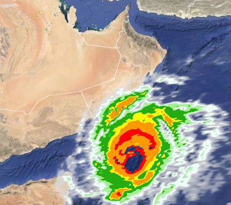
Even as Cyclone Chapala is downgraded to a tropical depression and is expected to completely dissipate today (Wednesday), Yemen is picking up the pieces in the aftermath of the devastation, which has destroyed homes and flooded city streets and villages.
According to the UN Office for the Coordination of Humanitarian Affairs, the effects of this cyclone will be felt over large parts of Yemen, which likely to be more severe in Shabwah and Hadhramaut, which have a combined population of about 1.8 million people.
This includes more than 100,000 internally displaced persons and 27,000 refugees and migrants.
In preparation for the health impact of the cyclone, the World Health Organisiation (WHO) has delivered trauma kits for 1,000 patients in Al Mukalla district of Hadramaut governorate.
WHO is also providing 20,000 litres of diesel to eight hospitals to ensure continued operation, as well as 2,500 litres of petrol for 16 ambulances to continue to provide emergency services.
A Strategic Health Operations Centre has been established in the WHO office in Sana’a while the Ministry of Public Health and Population continues to function from its WHO-supported operations room.
In addition, WHO’s sub-office in Aden is on alert and working with partner agencies in the south to finalise their plans.
Mohammed Alarqbi, a resident of Socotra Island, which was one of the worst-hit places, cited the local authority in damage estimation in a Facebook update, saying 117 homes were completely destroyed, while 612 homes partially damaged.
203 motorised fishing boats were destroyed or are missing.
Hundreds of dead animals and palms litter the small island’s streets.
EARLIER REPORT
Cyclone Chapala slams into Yemen, floods Mukalla, thousands flee
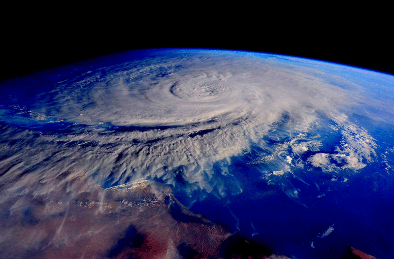
A rare tropical cyclone has slammed into Yemen, triggering heavy flooding and causing ‘enormous’ damage, a senior official said Tuesday.
Packing winds of more than 100km per hour, Cyclone Chapala made landfall in the southeastern provinces of Hadramawt and Shabwa, Minister of Fisheries Fahd Kafain said.
"The damage is enormous and we fear human losses," said the minister, part of a commission set up to deal with the cyclone that brewed in the Arabian Sea.
The storm earlier wreaked havoc on the island of Socotra located 350km off the Yemeni mainland.
More than 200 people were injured and dozens of houses and hamlets were severely damaged or washed away, said Salem Zaher, mayor of the island's main district Hadibo.
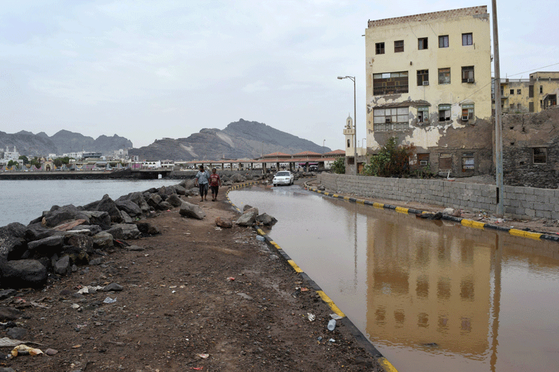
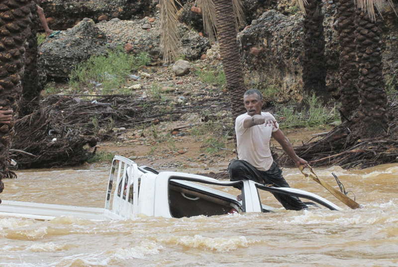
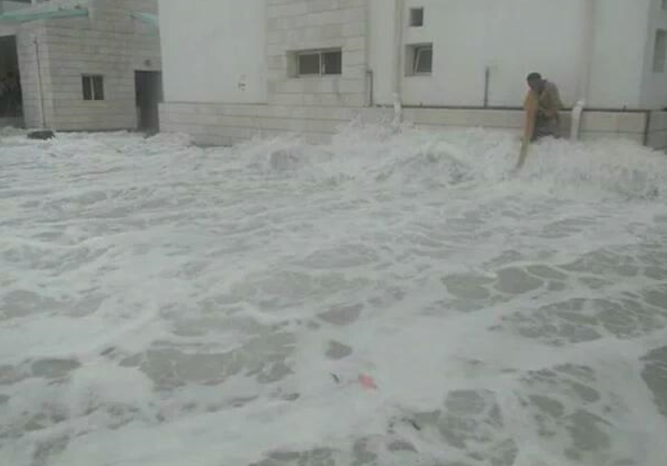
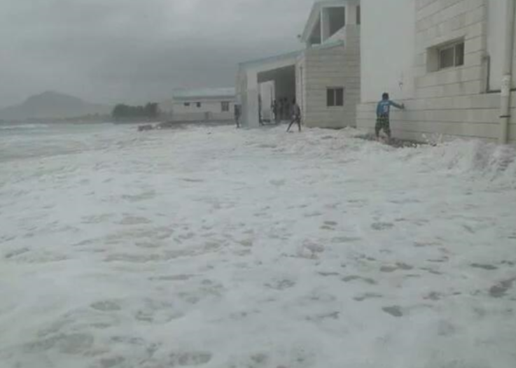
Images posted on social media showed heavy floods hitting the streets of Mukalla, the provincial capital of Hadramawt.
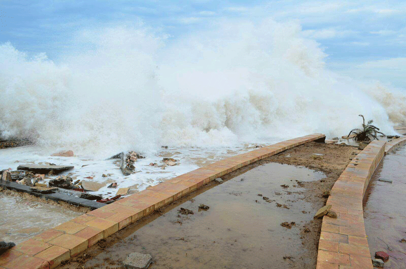
Cars were half-submerged in muddy water while seafront roads were badly damaged by high waves.
"The rainfall from Chapala is far beyond anything ever witnessed in this arid area which is not used to cyclones," the UN weather agency said on Monday.
The ‘very severe cyclonic storm’ brought maximum sustained winds of 130km per hour with gusts of up to 145km per hour when it made landfall, it said in a joint update on Tuesday with India's meterological agency.
But the cyclone had since lost strength and was expected to weaken into a tropical depression during the next 12 hours, it added.
Oman downgraded its state of alert, saying the cyclone had moved westwards and would not directly hit the sultanate.
However, the Omani meteorological agency warned that waves as high as three metres (10 feet) were still expected to hit the shores of Dhofar and Al Wusta provinces.
The cyclone, with hurricane-force winds, made landfall on Yemen's Arabian Sea coast on Tuesday, flooding the country's fifth-largest city Mukalla and sending thousands of people fleeing for shelter.
Officials and meteorologists say the storm is the most intense in decades in the arid country.
In the provincial capital Mukalla, water submerged cars on city streets and caused dozens of families to flee to a hospital for fear of rock slides.
Residents said the seafront promenade and many homes had been destroyed by the cyclone, and officials in the dry hinterland province of Shabwa said about 6,000 people had moved to higher ground.
"The wind knocked out power completely in the city and people were terrified. Some residents had to leave their homes and escape to higher areas where flooding was less; it was a difficult night but it passed off peacefully," said Sabri Saleem, who lives in Mukalla.
There were no initial reports of injuries.
The cyclone first hit the remote Yemeni island of Socotra, killing three people and displacing thousands.
Meteorological agencies predicted Chapala would hit land around Balhaf, site of Yemen's liquefied natural gas terminal, and weakening as it advanced towards the capital Sanaa in the country's north.
The facility has been mostly shuttered since the start of a war in March.
It was not immediately clear if the terminal, once a lifeline for Yemen's economy, suffered damage.
EARLIER REPORT: As Tropical Cyclone Chapala makes landfall in Yemen, the wrath of the storm continues to weaken as it tracks northwest.
Those living in Yemen’s coastal areas are being warning of wave height reaching 22 feet.
Forecasters further state, Chapala has the potential to dump at least three to four times the average yearly rain in just a day or two over parts of eastern Yemen.
According to the current estimate by the US Navy’s Joint Typhoon Warning Centre, as of November 3, 6am UAE time, the weather system is located approximately 25 Nautical Miles or 43 kilometres from mainland Yemen’s southern port city Al Mukalla.
#حضرموت #المكلا_الان فيديو مباشر من شوارع #المكلا #اعصار_تشابالا #عمان #المهرة #السعودية #الامارات #اليمن #عدن pic.twitter.com/ExkkmpeQNh
— عدن الآن (@AdenNowNews) November 3, 2015
Video of flooding Al Mukalla, by Sara Al Aidarous on Twitter
The cyclone has tracked eight knots over the past six hours.
The intensity of the storm remains at nearly 140kmph.
According to Oman Met, already 200mm of rainfall has been forecasted over the Shabwa and Hadramout governates in Yemen, with wave heights reaching 10m.
While Oman Met has downgraded Chapala to a Tropical Storm, the JTWC and several other forecasters are still referring to the system as a Category One Cyclone as it makes landfall.
Safety advisory
While Al Mukalla fears impact of Chapala, the Oman Met office has stated it is recording wide activity of the thunderstorms cells on the Yemen coasts to coincide with the eye’s approach.
Residents of Yemen have taken to social media warning the 300,000-odd residents of Al Mukalla to take precaution by moving further inland, or piling sandbags in front of their homes to keep the rising flood waters out.
Others are also being advised to keep emergency kits with flashlights and first aid kits handy as the storm makes landfall.
Meanwhile, in its last advisory, neighbouring Oman’s Public Authority of Civil Aviation or PACA has stated an immediate impact of Cyclone Chapala has ended on the country, disregarding the occasional thunderstorm in the districts of Al Dhofar and Al Wusta, which could also face rough seas and waves of five metres for another 24 hours.
Cyclone Chapala was approaching Yemen on Monday after wreaking havoc on Socotra island and injuring hundreds of people there, as fears of its impact on Oman eased, officials said.
Strong winds hit southeast Yemen and high waves flooded Mukalla and Shehr in Hadramawt province, as well as the Belhaf gas terminal in Shabwa province, officials and residents said.
"The cyclone is approaching Mukalla and we fear a disaster," one official at the provincial capital said, requesting anonymity.
شاهد فيضانات #المكلا في #اليمن صباح اليوم بسبب #اعصار_تشابالا pic.twitter.com/MOhRfhPXo3 - من حساب @AdenNowNews
— الطقس (@FAHAD_1322) November 3, 2015
Videos and images posted on Twitter by Sara Al Aidarous, depicting floodwaters gushing through the creek in Al Mukalla in wake of Cyclone Chapala "Families have evacuated coastal areas and residents are organising themselves and helping each other to deal with the cyclone," he added.
On Socotra, "more than 200 people were injured and dozens of houses and hamlets were either heavily damaged by water or washed away by waves," said Salem Zaher, mayor of the island's main district Hadibo.
Socotra is less than 250 kilometres (150 miles) from the Horn of Africa and 350 kilometres off the Yemeni mainland.
It has 50,000 inhabitants, mostly fishermen.
Cyclone Chapala kills 3 on Yemeni island
A rare tropical cyclone packing hurricane-force winds killed three people and injured scores on the Yemeni island of Socotra on Monday, residents and officials said, and then headed for a town on the mainland.
Amateur pictures and videos on social media, which could not be immediately verified, showed torrents of water washing through the streets of the Socotra provincial capital Hadibu.
"Three people were killed, around 100 have been injured," said a local official, without describing the causes of death.
EARLIER REPORTS
Oman’s National Committee of Civil Defense has tweeted on its official Twitter account that thousands of residents were evacuated in parts of Salalah and Dhofar in wake of Cyclone Chapala.
The authority tweeted: “In Dhofar: 12 shelter centers. Total of 4,267 person were sheltered (206 citizens and 4,061 foreigners).”
Meanwhile, in Al Wusta one shelter has been set up in a school where three Omani families comprising 25 citizens were moved on Sunday, following the evacuation.
Sectors of the National Emergency Management System deployed incident command teams in Dhofar by Royal Oman Police & National Armed forces.
Back-up generators are also positioned in Dhofar in wake of power cuts.
The Yemeni island of Socotra near the entrance to the Gulf of Aden was lashed on Sunday by strong winds and rain, damaging dozens of homes, an official said.
Click to read: Socotra villages swept away, says eyewitness
فديو لكورنيش مدينة المكلا جنوب اليمن صباح اليوم وارتفاع الامواج ومتوقع ان تتأثر بالامطار منتصف الليل #Chapala pic.twitter.com/yVqegEuq6S
— ابو نايف التميمي (@ABONAIF_ALTAMIM) November 2, 2015
The storm presaged the approach of cyclone Chopala, which is expected to hit the Yemeni mainland and Oman on Monday.
"More than 80 houses were damaged on the coast of Socotra and hundreds of people were rescued and hospitalised," Salem Zaher, the Mayor of Hadibou, the island's main town, told AFP.
"More than a thousand families were evacuated and resettled in schools and camps" inland amid "intense rainfall and strong winds", he added.
The UN's weather agency said that the "super cyclonic storm" named Chapala was expected to make landfall at around midnight on Monday in Yemen and Oman.
It said Chapala's wind speed was the equivalent of a category four hurricane.

Different branches of the Oman Armed Forces, including the army and the navy have been deployed to assist with the relief efforts in the governate of Dhofar, Salalah, in wake of Cyclone Chapala. (Pics, courtesy official Twitter account of Oman’s National Committee of Civil Defense)
Omani authorities ordered schools closed on Sunday and Monday in the southwestern province of Dhofar, ONA state news agency said.
It said satellite images have shown that Chapala was approaching the shores with wind speeds between 220 and 250 kilometres (136 and 155 miles) per hour.
Oman's civil aviation authority warned that waves higher than seven metres (23 feet) were expected to hit the beaches of Dhofar.
Socotra hit
A rare and rapidly intensifying cyclone killed one person and injured nine Sunday on the remote Yemeni island of Socotra as it moved toward the Yemeni mainland, local security officials said.
The officials said Cyclone Chapala seriously damaged or destroyed at least 20 homes on the island.
They said many residents living near the coast are taking shelter in caves or in schools. The island is being hit by heavy rain and strong winds, and rising waves are battering the coast. The officials said coastal areas are flooded.
Mohammed Salmein, a resident of the island, said they haven't seen winds and rain like this in decades.
"We are expecting a true disaster to befall us," he said, "and only God knows whether we will last until tomorrow."
Socotra island lies in the Indian Ocean some 230 miles (368 kilometers) off the coast of Yemen's mainland. It is known for its unique vegetation and ecosystems, including rare dragon blood trees.
The UN weather agency said on Friday that Cyclone Chapala could dump more than a year's worth of rainfall on the arid, impoverished and war-torn country.
The Global Disaster Alert and Coordination System forecasts the storm will make landfall in Yemen around midday Tuesday, following earlier estimates that it would hit on Monday. It said that up to 390,000 people could be affected by the wind speeds, and 3,500 people residing in coastal areas could be affected by storm surge.
In Al Mahra, Yemen's easternmost province, security officials said dark clouds are forming amid unusually strong winds, though no damage has been reported yet.
Mukalla is evacuating a coastal neighborhood which is one of the oldest in the city.
All officials spoke on condition of anonymity because they were not authorized to speak to journalists.
According to the 6pm update by Oman Meteorology, Cyclone Chapala currently lies 400km away from the governorate of Dhofar, with wind speeds of up to 171kmph.
During the next 12 hours, the cyclone is expected to be downgraded to a category one storm.
Coastal areas around Dhofar have been evacuated by the Omani authorities, while neighbouring Yemen faces flooding and gale winds on Socotra Island.
Oman Met office further adds: "The centre of Chapala is expected to cross the coastal areas of Yemen as a tropical cyclone category one storm in the next 36 hours.
"Heavy rain and occasional thundershowers associated with fresh winds are expected to affect the Dhofar governorate.
"Torrential rains with fresh to strong winds also expected, associated with rough to very rough sea conditions with wave height reaching five to seven metres."
 (Picture by Ahmad)
Satellite imagery indicates Chapala is approximately 160km off the coast of Socotra, with reports on social media indicating the island is facing severe flooding and homes collapsing in wake of wind speeds reaching 185kmph.
 (Picture by Ahmad)
EARLIER REPORT
In its noon update, the Oman Meteorology Department has warned of waves reaching heights of nearly 33 feet and wind speeds accelerating to 170kmph as Cyclone Chapala hits Yemen’s Socotra Island.
Oman is also bearing the brunt of the storm with waves reaching 23 feet high, while rainfall is expected to exceed 20mm in the governorate of Dhofar.
In a series of tweets on its official Twitter account, the Oman met office stated: “The sea state over Socotra Island is very rough with maximum wave height of 10m (33 feet).
“The weather forecast over the Republic of Yemen for Socotra Island is heavy thunder showers, which may exceed 500mm with very strong wind up to 170 kmph.”
It continued: “Al Mahra governorate of Oman could see potentially heavy rain in the evening (Sunday), with rainfall exceeding 70mm and wind speed reaching 70kmph.”
The Hadramaut governorate could see maximum wave height of seven metres or 23 feet.
Residents stock up emergency ration
Residents of Salalah are reporting public beaches are closed, while several have stocked up on emergency food and water supplies as rainfall and thunderstorms commence in the area in wake of Cyclone Chapala.
Salalah resident Abdul Manaf NM told ‘Emirates 24|7’: “People were nervous on hearing the news that this cyclone will pour eight years’ rain in 48 hours.
“Public areas were not that much affected till yesterday. But today (Sunday) people are more likely to be inside their rooms and traffic is also less on the roads.”
Manaf said the wind picked up speed by afternoon, while Civil Defence authorities were patrolling the roads and warning people to avoid coastal areas.
Twitter user Suhail Rasheed also reported around noon that it has begun to rain in Salalah.
According to Oman Met, the centre of the cyclone is about 430km from Dhofar coast and 200km from Socotra Island.
EARLIER REPORT
Thunderstorms over Yemen's Socotra Island
At 10am UAE time on Sunday, the Oman Meteorology department stated Cyclone Chapala had tracked westwards, adding that the centre of the storm now lay approximately 430km from the Dhofar coastline and 200km from Yemen’s Socotra Island.
Salalah has already felt the impact of the storm, with Oman Met confirming heavy rainfall has commenced in the area, approximately 9am UAE time, measuring 5.8mm.
Evacuations begin
The Oman Met office has asked residents to follow regular updates across its social media platform, tweeting details in Arabic, English, Hindi and French languages.
Omani and Yemini governments have issued warnings and urged residents to evacuate coastal areas as the severe cyclone ‘Chapala’ approaches shores, reported local media.
Omani Royal Air force helped evacuate residents of Al Halanyat as well as people in Saadha Hospital to safer grounds.
In Yemen, President Abd Rabo Mansour Hadi, has briefed the emergency operations to be ready at all times.
Yemen’s civil aviation urged residents of Hadramawt, Shabwa, Al Mahra and Socotra areas to evacuate at the earliest.
30-foot waves expected
The November 1 weather update by Oman’s Multi-Hazard Early Warning Centre analysis reveals that the Tropical Cyclone Chapala over the south-western Arabian Sea is currently centered about 450km away from the coastal areas of the governate of Dhofar. The centre further states: “The surface wind speed around the centre has decreased to 85-95 knots (153 to 171 km/hour).
Latest weather charts indicate that Chapala is likely to track westwards, with the centre of Chapala expected to cross the coastal areas of Yemen in the next 48 hours.
The centre further warns: “Isolated moderate to heavy rain, occasional thundershowers associated with fresh winds, are expected to affect Dhofar governate on Sunday.
“Torrential rain with fresh to strong winds over the governate and rough to very rough seas condition with wave height reaching five to seven metres are expected on Monday and Tuesday.”
Maximum wave height is expected to reach 30 feet.
The Public Authority of Civil Defence and Ambulance (PACDA) in Oman is advising the public to take necessary precaution and stay away from low lying areas avoid crossing wadis. Fishermen and sea goers should also avoid venturing into the sea and follow latest updates issued by authorities.
Schools closed
The Yemeni legitimate government announced the suspension of classes in four coastal governorates because of the Hurricane.
The Command of Special Central Operations Room urged the local authorities about the Hurricane in the governorates of Hadramout, Socotra, Al Mahra, and Shabwa, to suspend the classes from Sunday until further notice.
UAE impact
Cyclone Chapala, a storm gathering in the centre of the Arabian Sea, may have no direct impact on the UAE, according to the National Center of Meteorology and Seismology (NCMS).
''Chapala may generate clouds in the south of the UAE as a result of a strong high pressure system on land and upper atmosphere extending from north-east Iran and Pakistan and east Caspian Sea.
“Accordingly, this will make it difficult for the tropical system to head towards the UAE,” the NCMS said in a statement.
Satellite images, weather numerical models and forecasts, the NCMS added, show that the tropical storm was moving towards southern coasts of Oman and Yemen and might reach the Gulf of Aden on November 2.
Cyclone threatens floods, damage in Yemen, Oman
Cyclone Chapala, a storm gathering in the Arabian Sea, is heading for Yemen and Oman and may cause floods, landslides and infrastructure damage in countries that are ill-prepared for such weather, Clare Nullis, spokeswoman for the World Meteorological Organisation (WMO) was quoted by Reuters as saying on Friday.
The UN climate agency said the tropical cyclone has strengthened very quickly in the past one day and is expected to become a super-cyclonic storm in the next 24 hours, with sustained winds of up to 230kmph (143 mph), equivalent to a Category 4 hurricane.
It is expected to hit the coast on Monday night.
"We do expect it will weaken before it makes landfall. It will probably be more on the lines of Category 1, but even so there will be very high gale force winds in an area that is just not used to seeing this," said Clare Nullis, spokeswoman for the World Meteorological Organisation (WMO).
"The winds are a threat but we expect the biggest impact will be from the very, very, very serious rainfall. I’ve seen some reports that the area might get the equivalent of more than a year’s worth of rainfall in a couple of days."
Nullis said the WMO was not aware of a tropical cyclone ever hitting Yemen before, although a cyclone that hit Oman in 2007 had done several billion dollars’ worth of damage and killed about 50 people.
The area of northern Yemen that is in the storm’s path is sparsely populated, but the Omani port city of Salalah is likely to be heavily affected, she said.
Salalah is Oman’s second largest city, with a population of about 200,000, and has a major container port managed by APM Terminals, part of A.P. Moller-Maersk
The winds are expected to slow to 150-160 kmph just before the storm makes landfall, and then slow further to 100-110 kmph.
The storm was caused by high sea temperatures and atmospheric conditions, but it was not clear if it was also caused by the El Nino weather phenomenon or by global warming, and if such storms might recur in future, she said.
"With climate change we’re really heading into unknown territory. We can expect to see things happening in the future that never happened in the past."
Earlier reports:
Oman is preparing to face Cyclone Chapala, which currently lies 850 km off the coast off Dhofar.
Warnings have been issued of possible flash floods, in wake of thunderstorms and torrential rain, even as a marine alert cautions of wave heights reaching 22 feet.
 Storm hit Kuwait Towers (AFP)
Residents are being told to move away from the coastline, with the cyclone's trajectory following a destructive path that, current estimates predict, will see it veer towards neighbouring Yemen's coastline.
In its Friday update, the Public Authority of Civil Defence and Ambulance (PACDA) in Oman stated: "The Multi-Hazard Warning Centre analysis reveals that the Tropical Storm over the central Arabian Sea has intensified into a Tropical Cyclone on Friday.
"The surface wind speed around the centre reaches 65 knots or 135kms per hour and centered 850kms from coastal area governorate of Dhofar."
The forecast further states the cyclone will track northwest towards Yemen, adding: "Heavy rain, thunderstorms, leading to flash floods over Al Wusta and Dhofar are expected starting Saturday evening."
The PACDA has also warned the Northeasterly winds, travelling from popular tourist destination of Ras Al Hadd - which houses the region's turtle reserve - until Dhofar will witness wave heights of 16 feet to 22 feet.
Possible rain in UAE, Oman
As Cyclone Chapala approaches the Oman coastline, residents are being warned of rough seas and fresh winds in the UAE over the weekend, with a chance of rainfall in parts of the country.
While the trajectory of the cyclone sees the weather system steer clear of the UAE, Oman remains on alert, while warning residents to avoid the coastline and wadis in lieu of possible flooding.
Residents of the UAE planning on taking advantage of the cooler climes to organise a road trip to the neighbouring country should heed to warnings issued by the Public Authority of Civil Defence and Ambulance (PACDA) in Oman.
As per the last update, Cyclone Chapala remains 850kms from Oman's Masirah Island.
The UAE has been experiencing heavy rainfall and waterlogging in parts of Ras Al Khaimah and Fujairah, with showers also recorded in Al Dhaid on Wednesday.
The country's National Centre for Meteorology and Seismology (NCMS) has further stated that Friday will see the chance of some convective clouds over the eastern mountains by afternoon, with fresh winds that could result in blowing dust over some areas and low visibility.
With Cyclone Chapala expected to gain momentum in the coming 48 hours to possibly turn into a very severe cyclonic storm according to forecasters, the NCMS has stated the waters of Arabian Gulf would be rough, along with the Oman Sea.
Temperatures, meanwhile, having been cooling off, with the mountains seeing the Mercury reach averages of 15 degrees Celsius, while the mean will hover in the mid-thirties around the coastal and internal areas.
On Saturday, the weather is expected to follow the same pattern as Friday, with a marine alert remaining in place.
The NCMS has also forecasted the relative humidity will increase during late night and early morning over some coastal and internal areas, especially towards west, which may give rise to mist or fog on Sunday.
![]() Follow Emirates 24|7 on Google News.
Follow Emirates 24|7 on Google News.