- City Fajr Shuruq Duhr Asr Magrib Isha
- Dubai 04:20 05:42 12:28 15:53 19:08 20:30

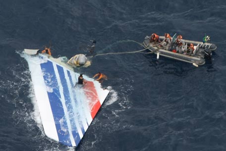
Brazil's Navy sailors recover debris from the missing Air France Flight 447 in the Atlantic Ocean. Geoff Dell, discipline leader of accident investigation at Central Queensland University, said if the black boxes of a missing Malaysia Airlines Flight MH370 were several kilometers (miles) deep, ships might need to be almost directly over them before the signal could detect them. (AFP)
Britain's Inmarsat used a wave phenomenon discovered in the nineteenth century to analyse the seven pings its satellite picked up from Malaysia Airlines Flight MH370 to determine its final destination.
The new findings led Malaysian Prime Minister Najib Razak to conclude on Monday that the Boeing 777, which disappeared more than two weeks ago, crashed thousands of miles away in the southern Indian Ocean, killing all 239 people on board.
The pings, automatically transmitted every hour from the aircraft after the rest of its communications systems had stopped, indicated it continued flying for hours after it disappeared from its flight path from Kuala Lumpur to Beijing.
From the time the signals took to reach the satellite and the angle of elevation, Inmarsat was able to provide two arcs, one north and one south that the aircraft could have taken.
Inmarsat's scientists then interrogated the faint pings using a technique based on the Doppler effect, which describes how a wave changes frequency relative to the movement of an observer, in this case the satellite, a spokesman said.
Britain's Air Accidents Investigation Branch was also involved in the analysis.
The Doppler effect is why the sound of a police car siren changes as it approaches and then overtakes an observer.
"We then took the data we had from the aircraft and plotted it against the two tracks, and it came out as following the southern track," Jonathan Sinnatt, head of corporate communications at Inmarsat, said.
The company then compared its theoretical flight path with data received from Boeing 777s it knew had flown the same route, he said, and it matched exactly.
The findings were passed to another satellite company to check, he said, before being released to investigators on Monday.
The paucity of data - only faint pings received by a single satellite every hour or so - meant techniques like triangulation using a number of satellites or GPS (Global Positioning System) could not be used to determine the aircraft's flight path.
KEEPING TRACK
Stephen Wood, CEO of All Source Analysis, a satellite analytic firm, said it seemed that the investigators had narrowed down the area substantially. "But it's still a big area that they have to search," he said.
The incident is likely to spur a review of aviation rules, especially related to communications equipment and the ability to turn off a plane's transponder, he added.
But it is too early to say what that would entail because it remains unknown what caused the plane to divert from its original course.
"This type of incident will cause everyone who flies airplanes commercially with passengers to be really pressed for a whole new line of ways to keep track of their precious cargo," said Wood, a former U.S. intelligence officer who headed the analysis unit of DigitalGlobe Inc, a satellite imagery firm, until July 2013.
Inmarsat said for a relatively low cost its satellites could keep tabs on flights and provide the data exchanged between the air and the ground to help organise routes to save time and fuel.
Its systems, which are widely used in shipping, have been embedded into surveillance and communications technologies that allow air traffic controllers to build up a picture of where aircraft are, and to better manage routes.
"If you have that (...) capability you get a preferred routing at the right altitude that makes your aircraft more fuel efficient, but if you don't have it you have to fly lower and get less priority in air-traffic control," he said.
The system is used in planes in the North Atlantic, Inmarsat's vice-president for aeronautics, David Coiley, told Reuters earlier this month, but it is not commonly used in all parts of the world.
Sinnatt said on Monday that such a facility would cost about $10 per flight. "It is something we have been pushing the industry to do because it significantly adds to safety," he said. Other satellite providers are also developing tracking systems.
For complete Malaysia Airlines MH370 coverage click below
![]() Follow Emirates 24|7 on Google News.
Follow Emirates 24|7 on Google News.