- City Fajr Shuruq Duhr Asr Magrib Isha
- Dubai 04:20 05:42 12:28 15:53 19:08 20:30

In five years from now Dubai will look different. We all knew that, and Dubai will keep on changing. But did you know that also the names of streets and areas are about to change?
At the moment the Roads and Transport Authority (RTA) is undertaking a massive addressing system project, changing the names of existing streets, forming new area clusters and districts and naming these as well.
In order to suit the constant changes in Dubai’s infrastructure and road network and enable motorists to navigate easily on this complex network a new way-finding and addressing system has been developed.
“A total of more than 7,500 streets have been appointed for renaming, out of which approximately 500+ have already been changed,” said Maitha bin Adai, CEO of the Traffic and Roads Agency (TRA) at the RTA.
“As part of the new addressing system internal streets are numbered sequentially,” she continued. “To reduce the complexity and make it easier to remember them it was decided that these streets - which previously were referred to with numbers - will now be named.
“Once fully developed, Dubai is likely to have 250 fully-developed areas by 2030. These areas are commonly referred to as communities and will be demarcated based on the land use it encompasses and be surrounded by major roads, which act as their boundaries. This is done during the preparation of the area-wide planning by Dubai Municipality Planning Department,” she explained.
The communities on their turn will form larger districts, and each district will have a particular theme.
“For example, streets in a district as Jumeirah will have names bearing marine features duvh as boats, fishes, marine life, etc., since it is abuot beach and sea. Similarly, streets in Deira and Bur Dubai will have historical and heritage names, while inland areas as Mushrif and Al Awir will bear names of local trees, famous Arab personalities, poets, etc.”
Apart from existing places in Dubai, new areas are to comply with the new system. Hence, new communities in Dubai already demonstrate aspects of the new addressing system.
“Major projects that were implemented as per the new system include the ‘Al Khail Road Improvement’ projects along Sheikh Mohammed Bin Zayed Road, as well as Parallel Road projects, and they were found to be effective and acceptable,” said Maitha.
The project is being undertaken in stages, so as to create as little confusion as possible. However, a careful eye of the public is needed, as a familiar street may suddenly have a different name, although it still leads where it always did.
As such, what used to be Emirates Road is now Sheikh Mohammed Bin Zayed Road, while the previous Dubai Bypass Road has become Emirates Road.
Abdulla Omran Taryam Street has replaced Al Thuraya Street, and Al Saa’da Street has replaced First Al Khail Street from 2nd Za’abeel Street to Al Meydan Street, while Road 312 is now First Al Khail Street.
A little confusing, but the public will get used to it eventually, claims the RTA, adding that it requires a cultural shift where people first refer to maps to intellectually plan their route and then move along.
The new information will be visible on signage boards, with many locations already adapted to the new names. The street name, as well as the district this street is located in will be indicated on the board.
An explanation of these boards were published by the RTA earlier:
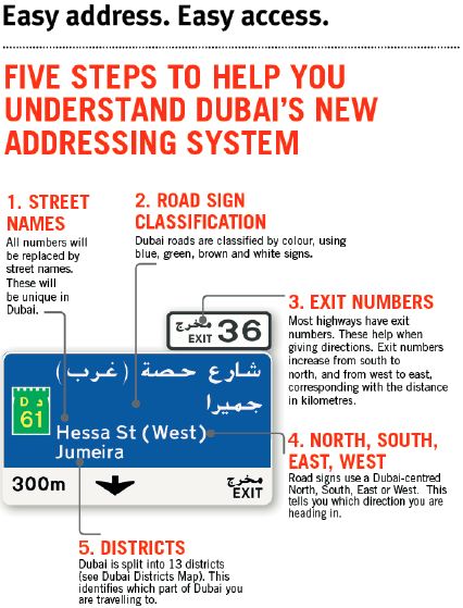
“To ensure success of the new system it was visualized that the components of the new signage system and the various elements that are built within it need to be explained to both motoring and non-motoring population, both residents and tourists and that too in a focused and targeted manner,” said Maitha.
“It is suggested that road users shall read and understand the system components, continually get up-to-date information about the new system by following their newspapers, read brochures, flyers and newspaper adverts and keep the latest tourist maps that are being published and distributed by RTA.
By understanding the system well people will be able to construct their own cognitive map that helps them in their way-finding.”
The first phase of the project includes replacing guide signs along Sheikh Zayed Road (E11) from the Abu Dhabi border until Al Garhoud Bridge, Financial Center Road (upper and lower levels) and Bukidra Interchange. This phase is planned for completion by the end of 2015.
![]() Follow Emirates 24|7 on Google News.
Follow Emirates 24|7 on Google News.