- City Fajr Shuruq Duhr Asr Magrib Isha
- Dubai 04:25 05:43 12:19 15:46 18:50 20:09

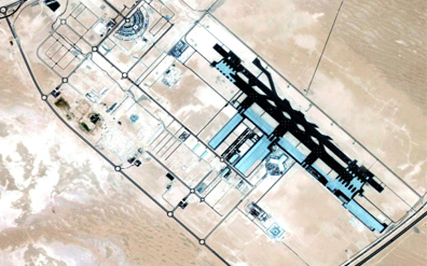
A DubaiSat-1 image of the Al Maktoum International Airport. (SUPPLIED)
The Emirates Institution for Advanced Science and Technology (EIAST) recently issued the image of the Al Maktoum International Airport taken by DubaiSat-1 while it was passing over the UAE.
The aerial image shows the airport after the inauguration of its first phase.
DubaiSat-1 is a stepping stone in UAE's attempt to create sound infrastructure that enables the collection of space and earth observation data to power the overall development of the UAE.
The satellite highlights the commitment of EIAST to create a knowledge-based economy by leveraging the advances in satellite technology.
DubaiSat-1 consists of two segments: space and ground. The space segment comprises the development, design and manufacture of satellite equipment and components of the measurement and imaging.
The ground segment includes the mission control station, image receiving and processing station, antenna and RF subsystem.
Images from DubaiSat-1 can be used for a variety of applications from urban development, scientific research, transportation to civil engineering and constructions, mapping and GIS.
DubaiSat-1 is the first remote sensing satellite owned by the UAE highlighting the country's commitment to possess advanced space technologies to fulfil the needs of scientific and technological research, as well as to provide up-to-date spatial and earth monitoring data that aids the holistic growth drive of the nation.
![]() Follow Emirates 24|7 on Google News.
Follow Emirates 24|7 on Google News.