- City Fajr Shuruq Duhr Asr Magrib Isha
- Dubai 04:20 05:42 12:28 15:53 19:08 20:30

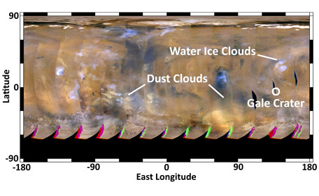
This global map of Mars was acquired on Aug. 4, 2012, by the Mars Color Imager instrument on NASA's Mars Reconnaissance Orbiter. One global map is generated each day to forecast weather conditions for the entry, descent and landing of NASA's Curiosity rover. The atmosphere is clear and seasonal around Gale Crater, in agreement with the computer models used to simulate Curiosity's landing. The dust storm southwest of Gale Crater, first seen on July 31, changed into an inactive dust cloud on Aug. 2, and now has dispersed even further. Dust activity is picking up on the other side of the planet, as shown by the dust clouds marked on the left side of the map. None of these dust clouds will arrive at Gale Crater before Curiosity does.
Image credit: NASA/JPL-Caltech/MSSS
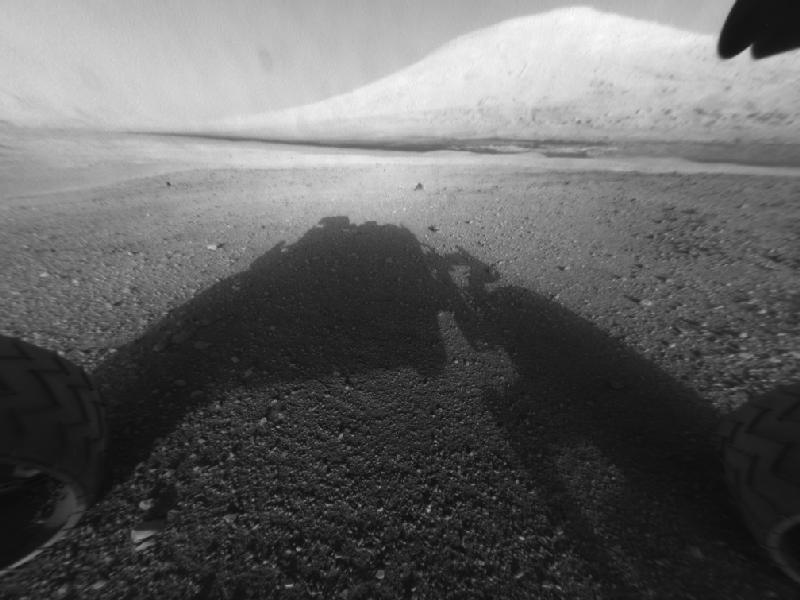
Behold Mount Sharp!
This image taken by NASA's Curiosity shows what lies ahead for the rover -- its main science target, Mount Sharp. The rover's shadow can be seen in the foreground, and the dark bands beyond are dunes. Rising up in the distance is the highest peak Mount Sharp at a height of about 3.4 miles, taller than Mt. Whitney in California. The Curiosity team hopes to drive the rover to the mountain to investigate its lower layers, which scientists think hold clues to past environmental change.
This image was captured by the rover's front left Hazard-Avoidance camera at full resolution shortly after it landed. It has been linearized to remove the distorted appearance that results from its fisheye lens.
Image: NASA/JPL-Caltech
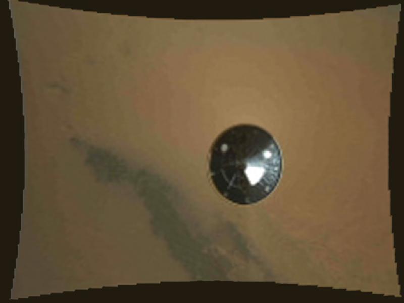
Curiosity's Heat Shield in View
This color thumbnail image was obtained by NASA's Curiosity rover during its descent to the surface of Mars on Aug. 5 PDT (Aug. 6 EDT). The image was obtained by the Mars Descent Imager instrument known as MARDI and shows the 15-foot (4.5-meter) diameter heat shield when it was about 50 feet (16 meters) from the spacecraft. It was obtained two and one-half minutes before touching down on the surface of Mars and about three seconds after heat shield separation. It is among the first color images Curiosity sent back from Mars. The resolution of all of the MARDI frames is reduced by a factor of eight in order for them to be promptly received on Earth during this early phase of the mission. Full resolution (1,600 by 1,200 pixel) images will be returned to Earth over the next several months as Curiosity begins its scientific exploration of Mars.
The original image from MARDI has been geometrically corrected to look flat.
Curiosity landed inside of a crater known as Gale Crater.
Image: NASA/JPL-Caltech/MSSS
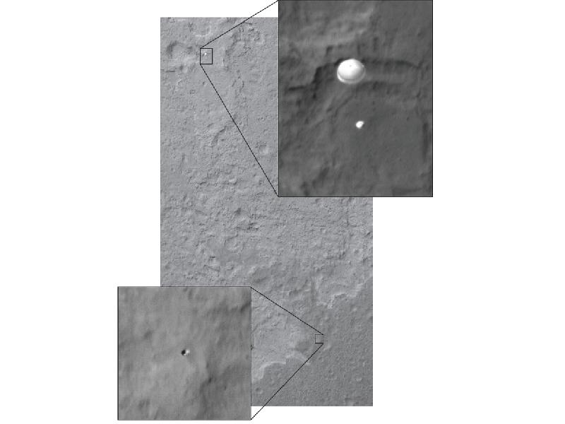 Curiosity Sails to Mars as Heat Shield Falls Away
Late last night, in the morning hours of Aug. 6, as NASA's Curiosity rover fell to the surface of Mars, NASA's Mars Reconnaissance Orbiter (MRO) captured an image of the rover gliding on its parachute. The image was taken with the orbiter's High-Resolution Imaging Science Experiment (HiRISE) camera.
Today, the MRO team located another object in this image -- not present in prior images of the same region -- which is the right size to be the rover's heat shield. The heat shield was ejected from the rover and its back shell before this image was taken. The team thinks the heat shield is still in free flight, because, if it were to have already hit the surface, it would have kicked up a dust cloud. The HiRISE image of NASA's Phoenix lander on its parachute also captured the heat shield in free fall.
Image: NASA/JPL-Caltech/Univ. of Arizona
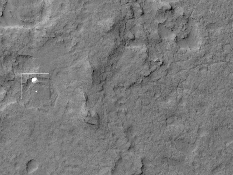
Curiosity Spotted on Parachute by Orbiter
NASA's Curiosity rover and its parachute were spotted by NASA's Mars Reconnaissance Orbiter as Curiosity descended to the surface on Aug. 5 PDT (Aug. 6 EDT). The High-Resolution Imaging Science Experiment (HiRISE) camera captured this image of Curiosity while the orbiter was listening to transmissions from the rover. Curiosity and its parachute are in the center of the white box. The rover is descending toward the etched plains just north of the sand dunes that fringe "Mt. Sharp." From the perspective of the orbiter, the parachute and Curiosity are flying at an angle relative to the surface, so the landing site does not appear directly below the rover.
The parachute appears fully inflated and performing perfectly. Details in the parachute, such as the band gap at the edges and the central hole, are clearly seen. The cords connecting the parachute to the back shell cannot be seen, although they were seen in the image of NASA's Phoenix lander descending, perhaps due to the difference in lighting angles. The bright spot on the back shell containing Curiosity might be a specular reflection off of a shiny
area. Curiosity was released from the back shell sometime after this image was acquired.
Image: NASA/JPL-Caltech/Univ. of Arizona
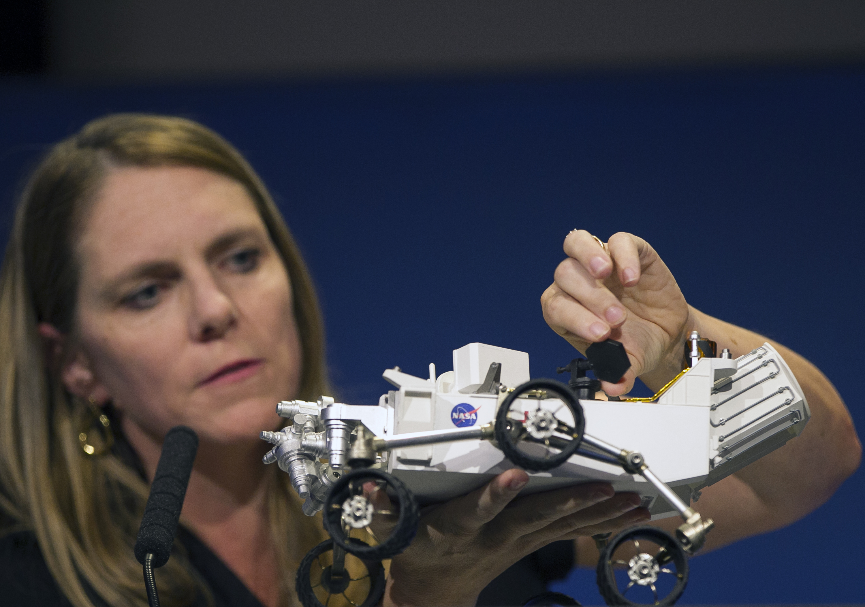
Jennifer Trosper, Mars Science Laboratory, MSL mission manager, JPL, adjusts the high-gain antenna on a rover model during a news briefing on the last data and imagery from Sol 1 at NASA's Jet Propulsion Laboratory in Pasadena, Calif., Monday, August 6, 2012. The rover's primary mission today will be raising its high-gain antenna, which will enable better communication with JPL scientists. (AP)
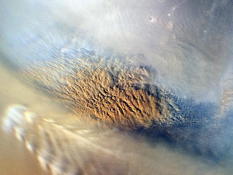
Martian Dust Storm
This close-up image of a dust storm on Mars was acquired by the Mars Color Imager instrument on NASA's Mars Reconnaissance Orbiter on Nov. 7, 2007, around 3 p.m. local time on Mars. Scientists working with NASA's Curiosity rover, which is set to land on Mars on Aug. 5 PDT (Aug. 6 EDT), are monitoring Mars each day for similar small storms that could either drift over the landing site or stir up dust that moves as haze over the site.
This image is centered on Utopia Planitia (53.6 degrees north latitude, 147.9 degrees east longitude), along the north seasonal polar cap edge in late northern winter. When NASA's Curiosity rover lands on Mars, it will be late southern winter. Scientists are looking at similar small storms that form near the south seasonal polar cap edge. The dust storm pictured here was short-lived, lasting less than 24 hours. The image also shows the seasonal north polar cap (at top of figure) and gravity-wave water ice clouds coming off of Mie crater, just south of the storm. Gravity-wave clouds, also called lee-wave clouds, are clouds that result from changes in atmospheric pressure, temperature and height because of vertical displacement, such as when wind blows over a mountain or crater wall.
Image: NASA/JPL-Caltech/MSSS
![]() Follow Emirates 24|7 on Google News.
Follow Emirates 24|7 on Google News.